
A Geological Mosaic
The Alsace wine-growing region stands on a tremendously varied, complex geology. And the Soultz wine-growing area is no exception to this rule. This very great diversity in the soils and rocks is due to a remarkable major geological phenomenon that occurred during the Eocene and Oligocene eras, 45–35 million years ago: the collapse of the Rhenish Trench. The origin of the Vosges mountains, the Black Forest, and the Plain of Alsace we know today, this phenomenon also revealed and juxtaposed geological strata of very different natures and ages, from granite to limestone, via sandstone, igneous, and schistose rocks.
Sandstone as a Common Thread
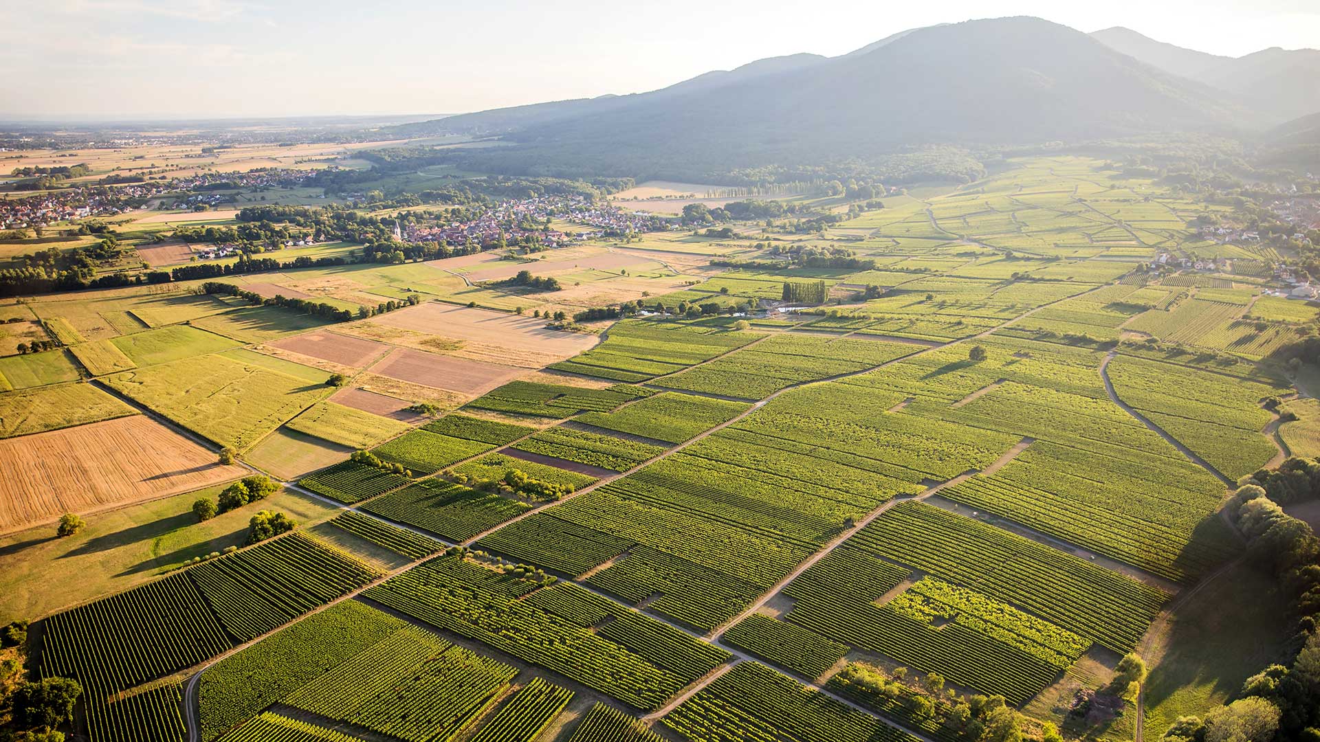
The wine-growing area of Soultz and its environs is lies in the Vosges foothills of the Rimbach Valley. These hills consist of pink sandstones formed during the Triassic era (250 million years ago) or limestones dating from the Jurassic and Oligocene eras (150 million and 35 million years ago respectively). Shaped and altered through thousands of years by geological movements, erosion, glaciers forming and melting, as well as by the activity of the flora and fauna, these rocks have given birth to a whole diversity of soils (sandstone, lime/sandstone, argillaceous limestone, and so on). Each with a real identity, these soils that constitute the base and the fundamental component of a wine-growing terroir.
The Localities: a Living Heritage
Certain localities are marked out by their soul, which may reside in the nature of their soil, the beauty of their landscape, their exposure, or the specific features of their climate. When these are shaped and maintained by successive generations of men and women, for example, in the form of a vineyard, we then speak of Terroirs.
In Soultz, these terroirs have for a long time been demarcated into several Localities, or noteworthy Crus. A document dating back to 1575 from the records of Thierenbach Priory indeed already notes four localities especially interesting for growing vines: “im Hornstein, am Mittelberg, am Orschwillerberg, am Bintzweg” (source: Médar Barth, Der Rebbau des Elsass, 1958). This document also reminds us that the names of localities in the Alsatian land registries are inherited from the region’s Germanic period.
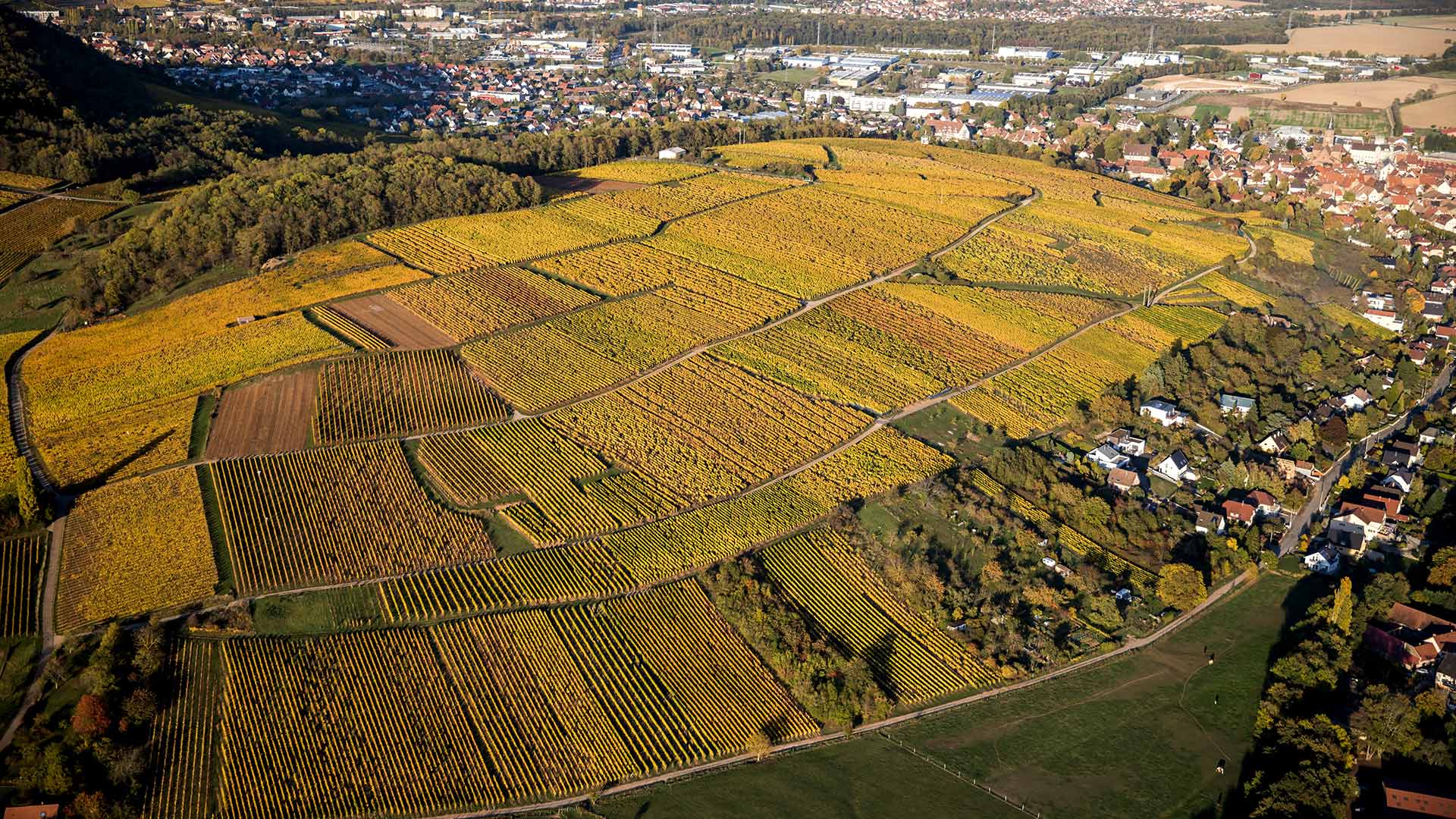
Today, the Domaine Robert Roth takes its place as a custodian of this living heritage. Clearly identified, three of these traditional terroirs cultivated at the Domaine have undergone plot-based vinification for around thirty years, in order to respect the identity and specific nature of each of these outstanding terroirs — Mittelbourg, Hornstein, and Soultz Orschwillerbourg.
MITTELBOURG
Mittelbourg is the historic terroir of the Roth family. Its history, its identity, and above all the high quality of its wines make it a perfect candidate for the new “Alsace Premier Cru” appellation currently being created.
Its Name
The origin of the name Mittelbourg, from the German Mittelberg, “the hill in the middle”, probably comes from its geographical situation: this hill is indeed wedged midway between the town of Soultz and the Vosges mountains.
Its Landscape
In the form of a dome, this relief typical of the Vosges foothills reaches an altitude of 360 metres. Its slopes can reach 45% in the steepest plots. Like some lookout post, it stands overlooking the town of Soultz and faces the Alsace Plain, the Black Forest, and in clear weather, the Bernese Alps. Its south-facing exposure makes this a particularly sunny terroir. At its summit and on its northern slopes stands a forest of ancient acacias along with several former orchards.
Its Soil
Its specific feature lies in the nature of its subsoil: framed by two geological faults, this is the only limestone relief in the Rimbach Valley. These are limestone conglomerates formed during the Oligocene era (35 million years ago). There are also hard, older limestones formed during the Jurassic era (150 million years ago), together with pink sandstone probably coming from the sandstone massifs neighbouring Mittelbourg. The calcareous sandstone soil is light, stony, and very shallow: 30–50 cm before reaching the limestone bedrock, which obliges the vines to develop their roots in the interstices of the rock in order to draw on the already scarce water. The red ochre colour of the soil is also remarkable and is due to the substantial presence of iron oxides.
HORNSTEIN

Its Name
The word Hornstein in German means “stone with horns” or “horned stone”. Sadly, despite a great deal of research, the origin of the name of this locality remains a mystery to this day.
Its Landscape
On the eastern slopes of the Mittelbourg hill, looking over the Florival and the town of Guebwiller, the Hornstein is a hillside bathed in morning sunshine, and hence cooler than its big brother Mittelbourg. The slope here is regular and pronounced (25–35%). Its average altitude is 330 metres, and its lower edges are bordered by small woods and old terraced vineyards, abandoned since World War II or eroded by the adjacent town. But its principal curiosity lies in its tower, erected on the north side in the 18th century by the De Heeckeren d’Anthès family for the sole purpose of using it during their holidays.
Its Soil
On the same geological base as Mittelbourg, namely a limestone substrate from the Oligocene (35 million years ago) with the presence of sandstone, it does however differ from that by the nature of its soil, characterized by a more significant proportion of marls and clays, making this a marl/limestone/sandstone soil. Heavier and thus richer, it also exhibits much higher water retention.
ORSCHWILLERBOURG
Its Name
The origin of the word Orschwillerbourg, from the German Orschwillerberg, has nothing to do with the village of Orschwiller in the neighbouring French department of Bas-Rhin. This name comes from the former village of Alschwiller (or Alswiller) that stood on this site until it was razed in the 13th century. Down the centuries, the word Alschwillerberg, or “Alschwiller Hill”, was gradually changed on the land registries to end up as Orschwillerberg, then Orschwillerbourg.
Its Landscape
The Orschwillerbourg is a small rise located between the Soultz plateau and the village of Hartmannswiller below. South-facing with only a slight slope (around 5%), it is bounded by a stream at the top end and by meadows and fields at the bottom. It has an average altitude of 260 metres, i.e. 100 metres lower than Mittelbourg, which is however barely 1½ km away.
Its Soil
Very different from the soils on Mittelbourg and Hornstein, the soil on Orschwillerbourg is actually a great deal younger. Formed in the Pleistocene era (2.5 to 0.1 million years ago), it is composed of sandstone scree, probably deposited when the glacier that occupied Rimbach Valley during the Ice Ages melted. It includes small rolled fragments of sandstone, together with quartz pebbles. This sandstone returned to the state of sand was then covered by silt from the erosion of the neighbouring mountains, which accumulated on this rise. The result is deep but quite light soil of marl-sandstone to silt-sandstone type, rich but with rather poor water retention.